Anyway, you can think of the major peaks in the Annapurnas as a crescent-moon shape, with the opening to the south and the peaks called Annapurna South and Hiunchuilli at the south-west tip of the crescent, and Machhupucharre, or fish-tail mountain (so-called because of it's twisted double peak), at the south-east. The two most famous treks here are the Annapurna Circuit, which goes around the outside of the mountains and takes about 20 days, and the trek to Annapurna Base Camp (also called the Annapurna Sanctuary trek), which takes you into the middle of the crescent moon and takes about 10 days round trip. Of course, there are tons of trails and we met people who had been in the Annapurna region (a protected area under the Annapurna Conservation Area Project, or ACAP) for 40 days and more! We took a simple 7-day trek starting in a village called Birethanti, south and west of Annapurna South. We walked north and east until we were literally 5 miles from Ann. South, cut across the mouth of the crescent moon to the Sanctuary trail near Fishtail, and turned south out of the mountains where we caught a taxi from Phedi back to Pokhara.
I should also explain that hiking up here isn't like it is back home in the States, or elsewhere in the world. The "trails" we're walking are really just the roads that the local people use to walk between the villages, farms, rivers, and cities of Nepal. There are little to no camping facillities anywhere along the road; instead, people stay in the guesthouses that have sprung up in each of the villages. Some are really nice, but most are just modest rooms with two beds, no heating, and plywood walls. If you're lucky, there's a toilet and shower inside the building somewhere. If not, there's at least a toilet outside. Accomodation at these guesthouses for doubles runs from about 100-200 Nepali Rupees (that's 70 NRs per dollar, so 100 NRs is about $1.50), and food is about the same. So in any given day, Justine and I spent about 2000 NRs, not including our guide.
Speaking of which, there's a new rule in Nepal that was implemented just days before we left: In addition to the ACAP entry fee (2000 NRs each), the Trekking Agents Association of Nepal (TAAN, which is just a travel agents' union) started requiring people to book treks through them, which costs an additional 250 NRs each. This means there is no more independent trekking in Nepal... you MUST book a porter (dude to carry your stuff), a guide (a dude to tell you where to go), or a porter/guide (a combo), AND the booking must be made through a unionized agent. We got a single porter/guide, named Bharat, to carry our one backpack (stuffed with a few clothes, two rented sleeping bags, meds, and our water filter) who is a friend of our hotel owner (Sabine).
On the first day, we took a taxi out to Birethanti from Pokhara, which took about 90 minutes, registered ourselves and our trek, and that's where I'll start. For height references, one meter is about 3.3 feet, Everest is 8848 m (~29000 ft), Mt. Whitney in California is 4421 m (~14500 ft), and altitude sickness usually sets in at about 3000 - 4000 m (~10000 - 13000 ft). Also, on our horse trek in China, we camped at almost 3500 m and the Ice Mountain lookout we went to was at 4500 m. Also, when we were in Pokhara, we spent 1100 NRs buying two trekking poles. Naturally, we left them behind in our hotel and bought two excellent bamboo poles for 100 NRs about an hour along on the trail; these would serve us extremely well. Okay, here we go:
Day 1 - 3.Nov
Birethanti (1025 m) to Uliri (2010 m).
Start time: 930 am
Lunch: Noon (1 hr)
End Time: 345 pm
Snack: 4pm (Pancakes and porrige)
Dinner: 715 pm (Daal Bhat, the traditional Nepali meal of Lentil soup, rice, veggies, pickels, and other stuff, depending on who makes it.)
Climbed the dreaded "Stone Staircase" today after descending an additional 100 m into a river valley and past a landslide which has killed the power in Uliri and other villages up here. At the start of the day, we were "asked" for a "donation" of 100 NRs to the Annapurna shrine. Saw many spectacular waterfalls and riverside scenery. The dogs here are huge and gorgeous, and the chickens numerous and cute! Of course, Justine is obsessed with them. Her Nalgeen went "missing," taken hostage by two teenaged Nepalis who seemed like they'd only give it back to me in exchange for money. We'll just buy another one when we get back to Pokhara, rather than give encouragement for steeling people's sh*t. Anyway, after lunch, we walked along a river for a short time before crossing over on a rickety suspension "bridge" and started up. The climb lasted for almost 2 hrs.!
Bharat, our guide, taught us to play Canongat (sp?), a billiards-type game played on a square table with giant tiddly-winks... you flick the cue disc (called the "shooter") with your fingers. The views of Annapurna South and the ridge across it to Hiunchuli were stunning after the clouds lifted. [See for yourself:
 ]
]The Maoist checkpoint at the start of the trail was efficient and professional, but lame anyway. At the lodge, a guy from Singapore and his 5 friends from HK lugged a bunch of Absolute vodka and limes up here. They gave us a bunch while Justine, Bharat, and I played cards and sipped Nepali tea. [ed. note: the Maoists are a group of rebel separatists in Nepal who have been waging war with the King until he relenquished power back in April and the democratic parties of the parliment (called the Seven Party Alliance) since at least 1999. Two days ago, the Maoist leader agreed to join the SPA and make the Maoists a ligit member of the Parliment, which means a cease-fire has been arranged. Almost none of the Maoist activity directly effects the tourism industry of Nepal, except for the trekking fees levied by the Maoists, which is a form of extortion, since it is not government authorized. Back in the day, Maoists roamed the trails with guns and took money as they saw fit, charging some tourists, specifically Americans, 100 USD! More recently, they have set up tables and started charging 100 NRs a day to everyone (except Nepali people) in the trekking regions, don't wave guns around tourists, and give you a printed reciept. Someone told me they sold their reciept to another American on eBay as a keepsake... why?]
Day 2 - 4.Nov
Uliri to Ghorepani (2750 m)
Start time: 845 am
Lunch: Noon (1 hr in Nangethanti)
Finish time: 2 pm (Hungry Eye Guesthouse)
Dinner: 6 pm (Dall Bhat)
I thought we were done with the stone staircase, but it just continued for another 1.5 hrs. this morning! We then entered an oak and rhododenderon forest area, whcih was much flatter and had beautiful rivers and huge waterfalls everywhere. We met a woman at lunch named Julia (from Seattle and who sounded exactly like Sarah Vowel) who knows all the same people in Pokhara as we do, even our guide, as this is her tenth time trekking in Nepal! A very small amount of rain fell on us today but the sun was strong, anyway. In the evening, we did laundry outside in the freezing cold wind, but used the fire inside to dry our stuff. We played cards with a Welsh couple (Tristan and Jess) who were finishing the Ann. Circuit trek on their own. Although we rented sleeping bags from Sabine, I got stuck with her daughter's bag, which barely covers me up to my chest. Tonight, I'll get blankets from the lodge and use those, instead. Tomorrow at 430 am, we'll start our walk up to Poon Hill at 3200 m to view the sunrise over the Annapurnas. I think there will be about a million people up there with us...
Day 3 - 5.Nov
to Poon Hill (3200 m)
Start time: 5 am
Finish time: 540 am
Breakfast back in Ghorepani: 8am
to Tadopani (2590 m)
Start time: 915 am
Lunch: 1 pm in Banthanti (1 hr.)
Finish time: 340 pm
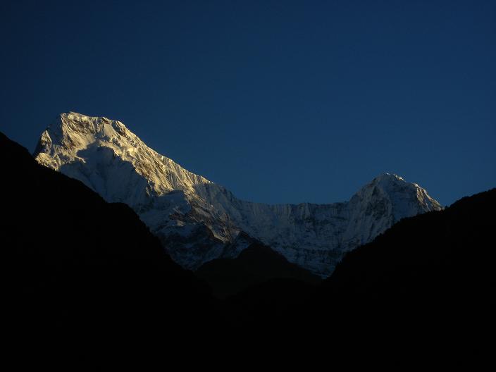
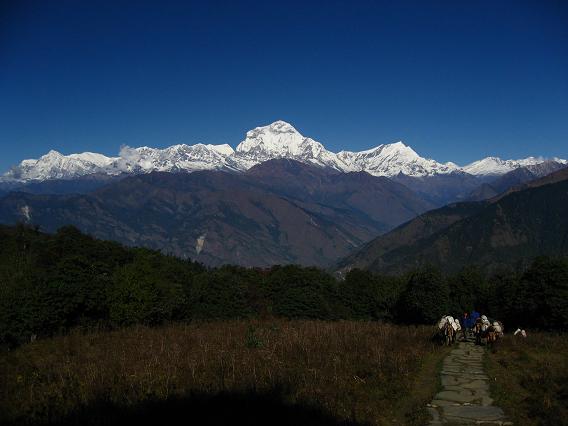
View of Dhaulagiri (far left, 8167 m, 7th tallest mountain in the world), and Annapurna I (8010 m, 10th tallest, with a bit of light on it at right) with Annapurna South (7219 m) just starting to get cutoff on the right.
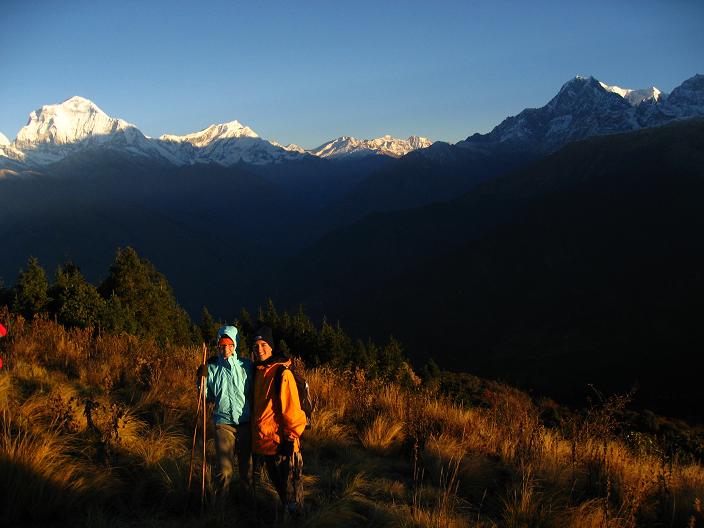
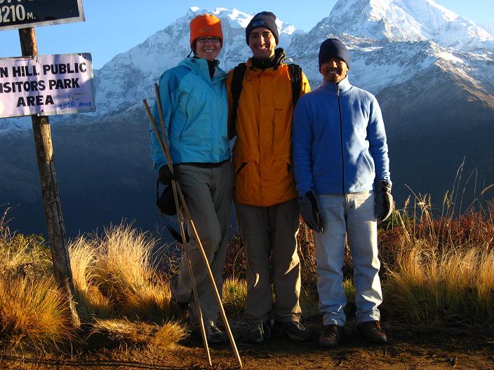
With our guide, Bharat, standing at the Poon Hill sign with Ann. I and Ann. South in the background.
The climb to Poon Hill was straight-forward but up a steep flight of stairs... I guess that's how all the trails/roads will be up here: Everything is "paved" with cut slate stones and the stairs are all uneven and so steep. But I guess that's the reason why: if they were dirt roads, everyone would be slipping and sliding everywhere and porters wouldn't be able to bring in supplies easily. ANyway, the sunrise views we shared with 100+ people in literally freezing weather were amazing, even though it was loud and annoying to be with so many people. I felt the views from the hill across from Poon Hill that we had around 10 am were far more rewarding and moving for the sheer silence. Also, the entire range was lit up and I swear you could see the earth's curvature from up there (see below). For the first part of the hike (after the better-view hill), we walked through an open and airy oak/bamboo forest area. The sun was bright, but the canopy above caused it to be just perfect inside, and the air was cool. For the first time, we walked on some Nepali-flat ground (a little bit up, a little bit down), but it wasn't as bad as the previous two days. The forest was like a happy, magical place, with views of the Himalays on the left and an open valley with trees of orange, red, and green on the right. After lunch, the trail went downhill past amazing river scenery, and the waters coming out of the mountains cascaded down countless 5, 10, and 20 foot waterfalls. We then started up a steep (they're all steep!) and exhausting ascent through a tropical, lush jungle... not quite the kind of terrain I'd expected in Nepal, but again, totally awesome. I think today was the most beautiful scenery I've ever seen anywhere, from the highest mountains in the world to colorful river valleys and open forest and jungle... we ran the gamut today! Unfortunately, we ended up in a dump of a place with a ton of loud Australian trekkers. The walls in our room don't reach the floor or ceiling, the windows don't close, and there's no light, but the food is good and we played cards all night again with Bharat and a German couple (Birget and ???), as well as another porter. We've been playing gin rummy and a game we call Big 2, but I think it's also called a$$hole. The funniest thing is that Bharat is totally enthusiastic and laughing and really enjoys playing. He's so excited when he wins, slamming down his last cards and gloating! Earlier today, he laughed for like 10 minutes when J joked about wanting me to carry her up the stone stairs... I thought he was going to pee himself.
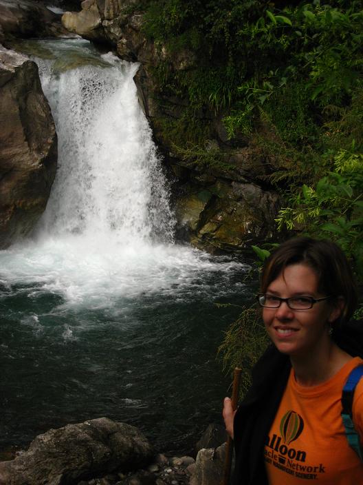
Okay... I can't really write anymore, right now, but I'll leave you with a few pictures of what happens later in the trip because I've already put them on the page. Briefly, the trek went off without a hitch, we got back and took Bharat out to dinner, and he cooked us Daal Bhat the next night. The day after that (which was yesterday, Saturday) we started some volunteer work at an orphanage in Pokhara and took the kids out to a Japanese-Nepali festival, which was really strange, as Nepali people were doing the cherry blossom dance and judo while Japanese dancers did traditional Nepali dance. Anyway, the last picture is not of our newly-adopted daughter, but of Justine and one of the kids from the orphanage. Enjoy, and hopefully I'll post days 4 through 7 tomorrow.
Walking through the forest on Day 3.

A better view of Dhalagiri from a hill neighboring Poon Hill (which is off the shot to the far left)... a team of horses carrying supplies are walking towards me out of the forsest along the path.
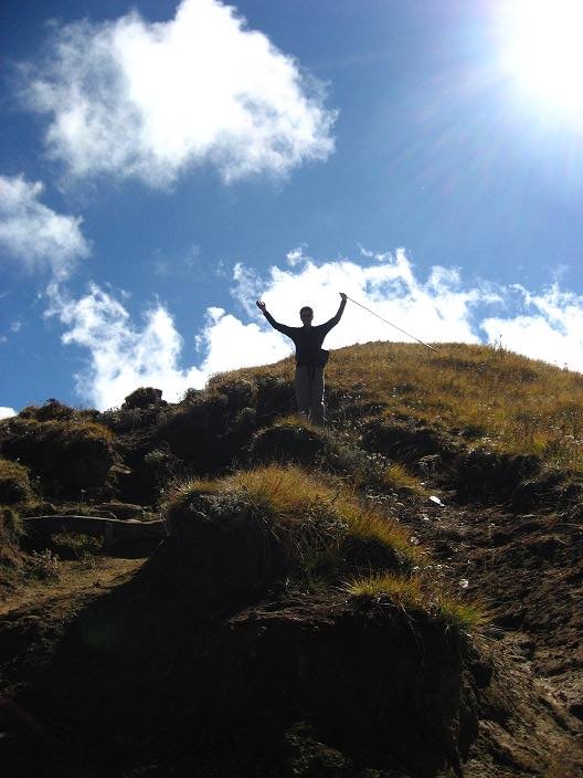
Mike with his bamboo pole standing near the summit of the hill near Poon Hill. The picture above was taken from near this spot, but facing the other way, so Poon Hill is off to the far right in this one.
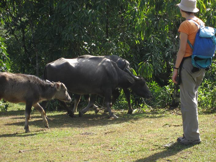
On the last day of our trek, Justine approaching a water Buffalo family near Dampus.
Playing "Big 2" with Bharat at Cafe Concerto in Pokhara after dinner on the night we returned from trekking

Bharat cooking us dinner at his home in Pokhara the night after we returned from trekking.

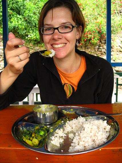
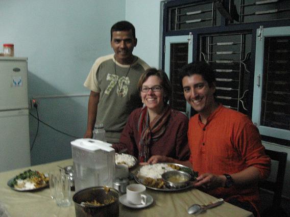
About to eat Bharat's Daal Bhat!
Justine and Mamata at the Nepali-Japanese festival.

-Mike
1 comment:
Those pix are amazing...I am so impressed but it is late so I havent read the whole post.
Go Sharks!
Post a Comment